Property photos
Freehold
Guide price
£20,000
Land for sale
Brill, Aylesbury HP18Tenure:
Freehold
Council tax band:
Not available
Local area information
Property location
Nearby amenities
- Brill Church of England School 1.7 miles
- Ashfold School 2 miles
- Bicester Village 5.6 miles
- Bicester North 6.2 miles
These distances are calculated in a straight line. The actual route and distance may vary.
Features and description
- Freehold
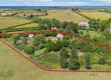
- A single enclosure of amenity pastureland
- Excellent road access
- 2.22 acres (0.9 hectares) in all
- Best & final offers Invited * 27th November 2023 midday *
2.22 acres of permanent pasture, bounded by mature hedgerows, with direct access and frontage to the public highway. Best & final offers Invited * 27th November 2023 midday *<br/><br>
The land, referred to as Lot 2 in the brochure, is situated in open countryside just south of the village of Ludgershall, 8 miles from the centre of Bicester. The land is accessible via a public highway and is located approximately ten miles from Junction 9 of the M40.
The sale consists of a circa 2-acre triangular enclosure of permanent pasture, bounded by mature hedgerows, with direct access and frontage to the public highway. The land is classified as Grade 4 on the land classification maps and there is a small pond to the southern boundary.
Services
The land does not benefit from any service connections.
Tenure
The land is freehold and sold with vacant possession.
Local Authority
Cherwell District Council
Overage/Development Clawback
The land is not being sold subject to any overage or development clawback provisions.
Public Rights of Way, Wayleaves and Easements
The land is sold subject to all rights of way, wayleaves and easements whether defined in this brochure or not. The land is crossed by a public footpath.
Basic Payment Scheme and Environmental Schemes
We believe the land has been registered for payments under the basic payment scheme but will not be available for transfer. We do not believe the land is entered into any stewardship scheme.
Sporting, Timber and Mineral Rights
The sporting, timber and mineral rights, so far as they are owned are included within the freehold of the sale.
Plans and Boundaries
The plans within these particulars are based on Ordnance Survey data and provided for reference only. They are believed to be correct, but accuracy is not guaranteed. The purchaser shall be deemed to have full knowledge of all boundaries and the extent of ownership. Neither the vendor nor the vendor’s agents will be responsible for defining the boundaries or the ownership thereof.
Viewings
By strict appointment through Fisher German LLP.
Directions
Postcode – HP18 9UH
what3words ///glider.glass.contemplate
From Ludgershall, proceed south on the Brill Road. After crossing the railway line, the land is the second gateway on the left of the road.
Floor plans and tours
Floor plans
No floor plan available
Tours
No virtual tour available
More information
Listed by
Property descriptions and related information displayed on this page are marketing materials provided by - Fisher German LLP. Zoopla does not warrant or accept any responsibility for the accuracy or completeness of the property descriptions or related information provided here and they do not constitute property particulars. Please contact Fisher German LLP for full details and further information.